


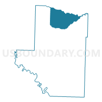
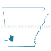
Redland Voting District, Hempstead County, Arkansas
About
Outline

Summary
| Unique Area Identifier | 526593 |
| Name | Redland Voting District |
| County | Hempstead County |
| State | Arkansas |
| Area (square miles) | 62.79 |
| Land Area (square miles) | 62.67 |
| Water Area (square miles) | 0.12 |
| % of Land Area | 99.81 |
| % of Water Area | 0.19 |
| Latitude of the Internal Point | 33.93166260 |
| Longtitude of the Internal Point | -93.62993170 |
Maps

Graphs
Select a template below for downloading or customizing gragh for Redland Voting District, Hempstead County, Arkansas


Neighbors
Neighoring Voting District (by Name) Neighboring Voting District on the Map
- Mine Creek Voting District, Hempstead County, AR
- Murfreesboro South Voting District, Pike County, AR
- Murfreesboro West 1 Voting District, Pike County, AR
- Ozan Voting District, Hempstead County, AR
- Pisgah Voting District, Pike County, AR
- Wallaceburg Voting District, Hempstead County, AR
Top 10 Neighboring County Subdivision (by Population) Neighboring County Subdivision on the Map
- Thompson township, Pike County, AR (2,424)
- Mine Creek township, Hempstead County, AR (1,535)
- Ozan township, Hempstead County, AR (1,337)
- Wallaceburg township, Hempstead County, AR (940)
- Redland township, Hempstead County, AR (693)
- Saline township, Pike County, AR (404)
Top 10 Neighboring Place (by Population) Neighboring Place on the Map
Top 10 Neighboring Unified School District (by Population) Neighboring Unified School District on the Map
- Nashville School District, AR (9,494)
- Blevins School District, AR (3,640)
- Murfreesboro School District, AR (3,183)
- Delight School District, AR (1,981)
Top 10 Neighboring State Legislative District Lower Chamber (by Population) Neighboring State Legislative District Lower Chamber on the Map
Top 10 Neighboring State Legislative District Upper Chamber (by Population) Neighboring State Legislative District Upper Chamber on the Map
Top 10 Neighboring 111th Congressional District (by Population) Neighboring 111th Congressional District on the Map
Top 10 Neighboring Census Tract (by Population) Neighboring Census Tract on the Map
Top 10 Neighboring 5-Digit ZIP Code Tabulation Area (by Population) Neighboring 5-Digit ZIP Code Tabulation Area on the Map
- 71852, AR (10,102)
- 71857, AR (5,894)
- 71940, AR (1,652)
- 71855, AR (708)
- 71847, AR (673)
- 71825, AR (645)